WESTERN TERMINUS/ROUTE 10 PROJECT
SELECTED ALTERNATIVE
The results of the conceptual engineering evaluation and the feedback from the stakeholder and public meetings have been reviewed, and an alternative has been selected for the Western Terminus / Route 10 Project. Alternative R2C (as presented during the Fall 2025 public involvement process) has been selected to proceed to Preliminary Engineering. Additional public meetings will be held in the future, as the project progresses and additional details are available.
SELECTED ALTERNATIVE: WESTERN TERMINUS / ROUTE 10 ALTERNATIVE R2C - MARCH 2026
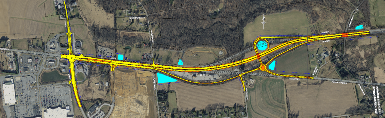
- U.S. 30 and Route 10 will remain as a signalized intersection with added lanes.
- U.S. 30 and Business U.S. 30 will become a grade-separated interchange.
- Interchange provides one single-lane roundabout and one loop road with no direct local road connection.
- Maintain right-in and right-out movements at Compass Road intersection to U.S. 30 and allow left turns into Compass Road for emergency vehicles only.
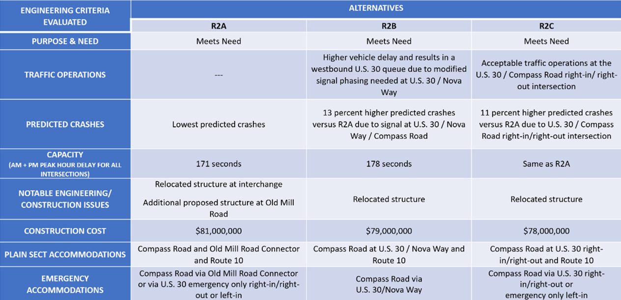
DECISION MATRICES
PROJECT BACKGROUND
EXISTING CONDITIONS
The existing interchange of US 30 and Business US 30 provides both eastbound and westbound on-ramps and off-ramps. The existing intersection of US 30 and PA Route 10 is an at-grade, signalized intersection.
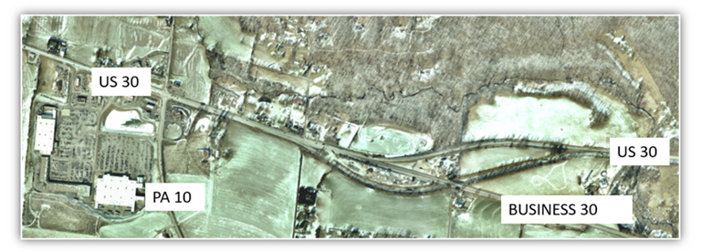
- The existing Western Terminus provides an eastbound on-ramp and connection to eastbound Business US 30.
- The existing Western Terminus provides a westbound off-ramp and connection from westbound Business US 30.
- The existing intersection of US 30 and PA Route 10 is signalized.
PURPOSE AND NEEDS
Purpose
The purpose of the project is to provide a safe and efficient transportation system by improving safety, reducing future congestion, accommodating planned growth, and improving facility deficiencies.
Needs
The project needs have been identified: Safety, Facility Deficiencies, and Congestion/Anticipated Growth
- Safety – Several locations within the project corridor have crash rates that exceed the statewide average for the same type of facility. Peak travel time congestion, narrow or absence of shoulders, and inadequate signalization and traffic signal phasing contribute to the high crash rates.
- Facility Deficiencies – Substandard roadway conditions exist throughout the project corridor. The existing pavement within the project area is approaching the end of its useful service life. The outer (right) shoulders are narrow and deteriorated. Two structures currently have insufficient vertical clearance.
- Congestion/Anticipated Growth – The existing traffic at the signalized intersection of US 30 and PA 10 currently exceeds the capacity during certain periods of the day, which results in congestion and driver delay. In the future, growth is anticipated to continue along US 30 and PA 10 in the area, resulting in higher vehicular traffic volumes and further congestion and delay.
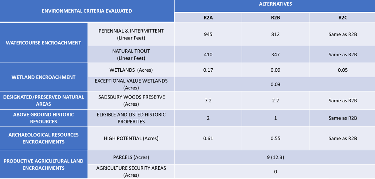
ENVIRONMENTAL RESOURCES
Some of the significant environmental features of the immediate project area include farmland, a nature preserve, township open space, two historic properties, five streams, and 8 wetlands. A total of 9 active agricultural parcels are present, one of which is in the Sadsbury Township Agricultural Security Area. The Sadsbury Woods Preserve owned by the Natural Lands Trust is located to the north of US 30. Sadsbury Township open space used for recreation abuts the preserve. The two historic properties lie along the highway west of the US 30/Business US 30 merge. Buck Run is the main stream present and, along with its tributaries, supports natural trout reproduction. One of the wetlands present is an open-water pond. The rest of the wetlands support predominately emergent vegetation. All the wetlands are considered to of exceptional value due to their connection with the Buck Run.