AIRPORT ROAD PROJECT
A virtual public meeting was hosted online on November 14th, 2024 at 6:00 PM. The project team gave a 30-minute project update presentation, followed by a question and answer period. A recording of the presentation can be viewed below.
An In-Person Public Meeting was held on Tuesday, December 3rd at 6:00 PM at the Coatesville Moose Lodge, located at 1200 Airport Road, Coatesville, PA 19320. This meeting was conducted as an open house where citizens had the opportunity to circulate among the subject display boards to receive the same project update information and to ask questions of the project team.
Comments and feedback were collected from the public during the virtual and in person events.
WELCOME AND PROJECT BACKGROUND
Thank you for visiting the project website. The US 30 Reconstruction program includes a series of projects that will upgrade the Coatesville-Downingtown Bypass (US 30) to improve safety, reduce congestion, accommodate planned growth, improve facility deficiencies, and improve system connectivity. In 2019, alternatives were presented to the public for the Airport Road Project Area (Section AIR). Based on the results of the conceptual engineering evaluation and the feedback from the stakeholder and public meetings, the Diverging Diamond Alternative was selected for the Airport Road Interchange to proceed to Preliminary Engineering. This public involvement process to occur in November and December 2024 will provide a project update and conclude the Preliminary Engineering stage.
After reviewing the information on this webpage, or through participation at virtual or in-person meeting, the public can provide input on the project by clicking the “Provide Your Input” button on this webpage. Hard copy comment forms will also be provided at the in-person public meeting. Please submit your input no later than December 13th, 2024.
AIRPORT ROAD PROJECT AREA
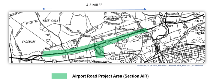
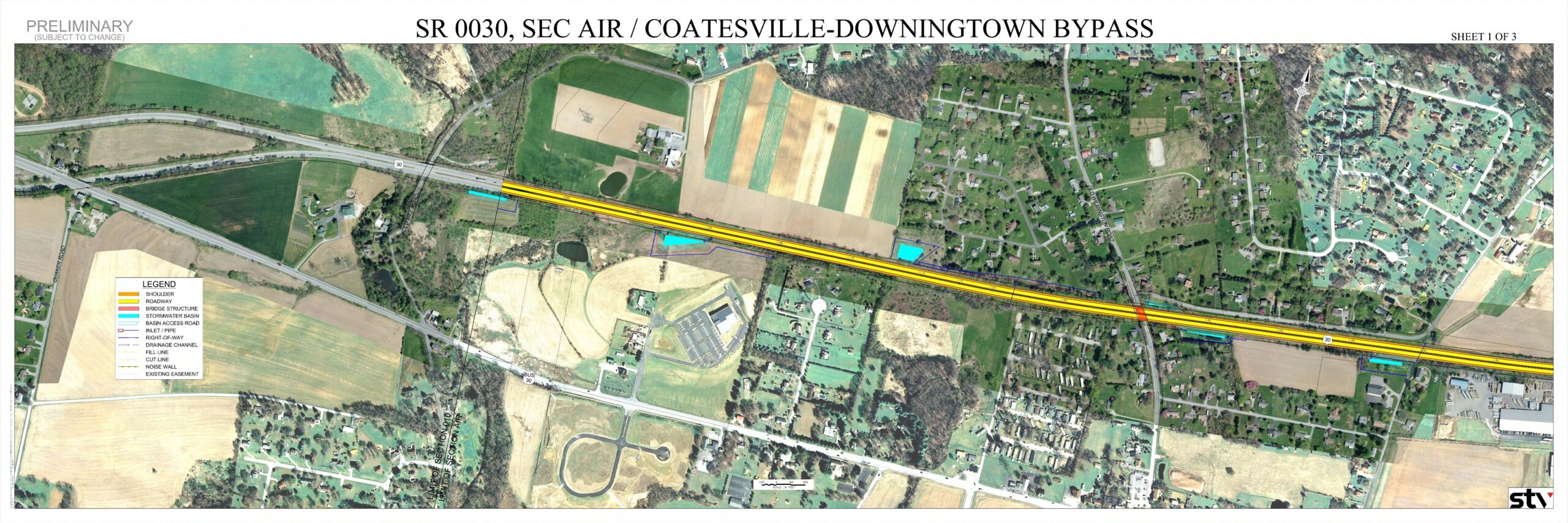
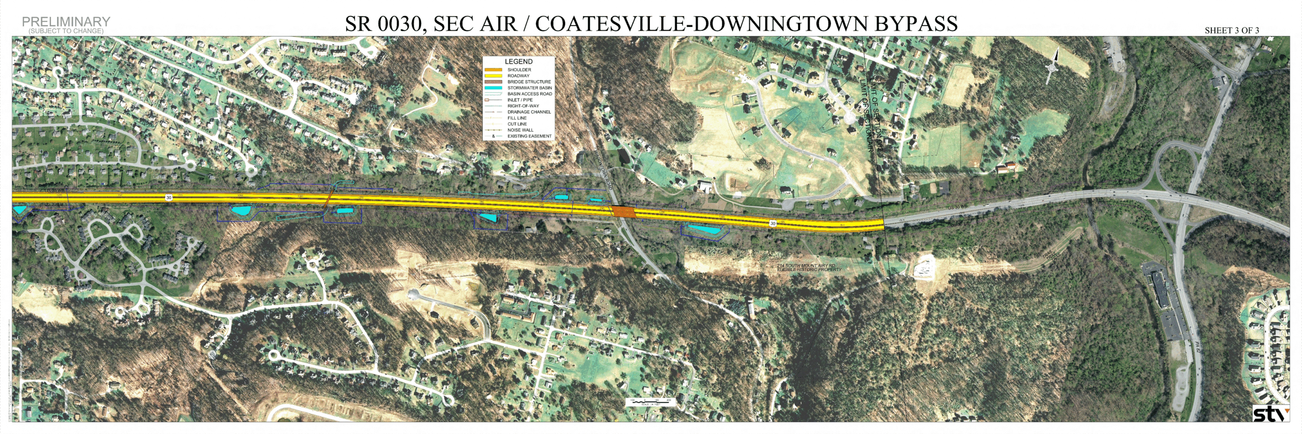
The Airport Road Project (Section AIR) includes approximately 4.3 miles of US 30 mainline, including the Airport Road Interchange. The project area also extends along Airport Road through US 30 Business.
EXISTING CONDITIONS
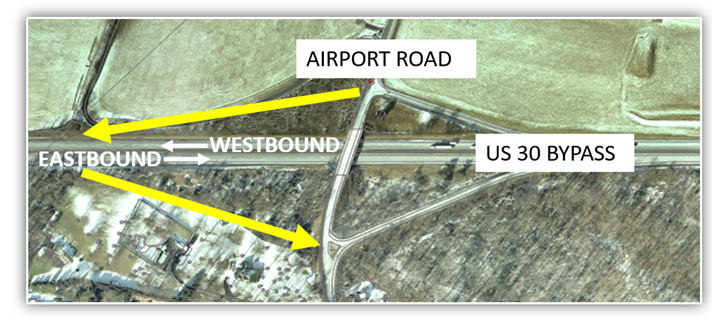
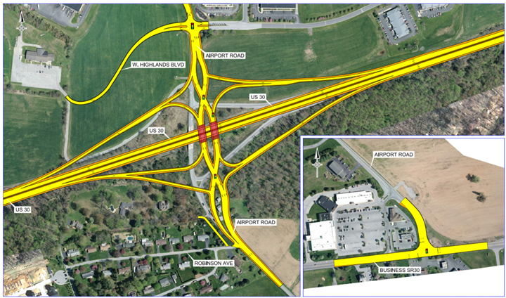
The existing interchange of US 30 and Airport Road provides a westbound off-ramp and eastbound on-ramp, as a partial interchange. The project will improve connectivity for the area by completing the interchange with the addition of a westbound on-ramp and an eastbound off-ramp.
PURPOSE AND NEEDS
Purpose
The purpose of the project is to provide a safe and efficient transportation system by reducing future congestion, accommodating planned growth, improving facility deficiencies, and improving system connectivity.
Needs
The project needs have been identified: Facility Deficiencies and Congestion/Anticipated Growth
- Facility Deficiencies – Substandard roadway conditions exist throughout the project corridor. The existing pavement within the project area is approaching the end of its useful service life. The outer (right) shoulders are narrow and deteriorated. The ramp deceleration and acceleration lanes are short. Two structures currently have insufficient vertical clearance.
- Congestion/Anticipated Growth – The existing Airport Road interchange lacks US 30 westbound entrance and eastbound exit movements. The missing movements negatively impacts the continuity of the US 30 corridor requiring the use of Business US 30 to accommodate the missing interchange movements. This results in congestion and delay along Business US 30. The US 30 westbound off-ramp intersection with Airport Road currently operates near capacity during certain periods of the day, resulting in congestion and driver delay. In the future, growth is anticipated to continue along Airport Road and Business US 30 in the area, resulting in higher vehicular traffic volumes and further congestion and delay.
US 30 MAINLINE
The existing typical section and the proposed typical section for US 30 mainline is illustrated in the graphic below. The proposed typical section has not changed from the previous public outreach.
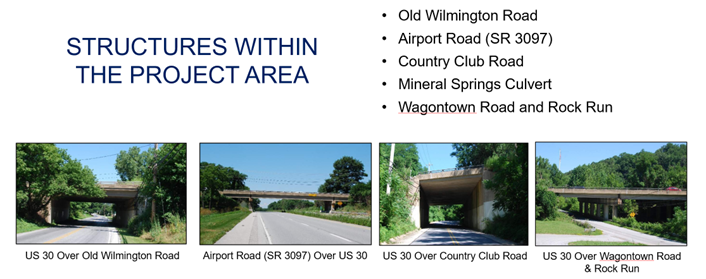
STRUCTURES WITHIN THE PROJECT AREA
There are five structures within the Airport Road Project Area (Section AIR), which will be replaced with the improvements.
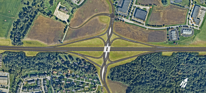
SELECTED PREFERRED ALTERNATIVE – DIVERGING DIAMOND INTERCHANGE
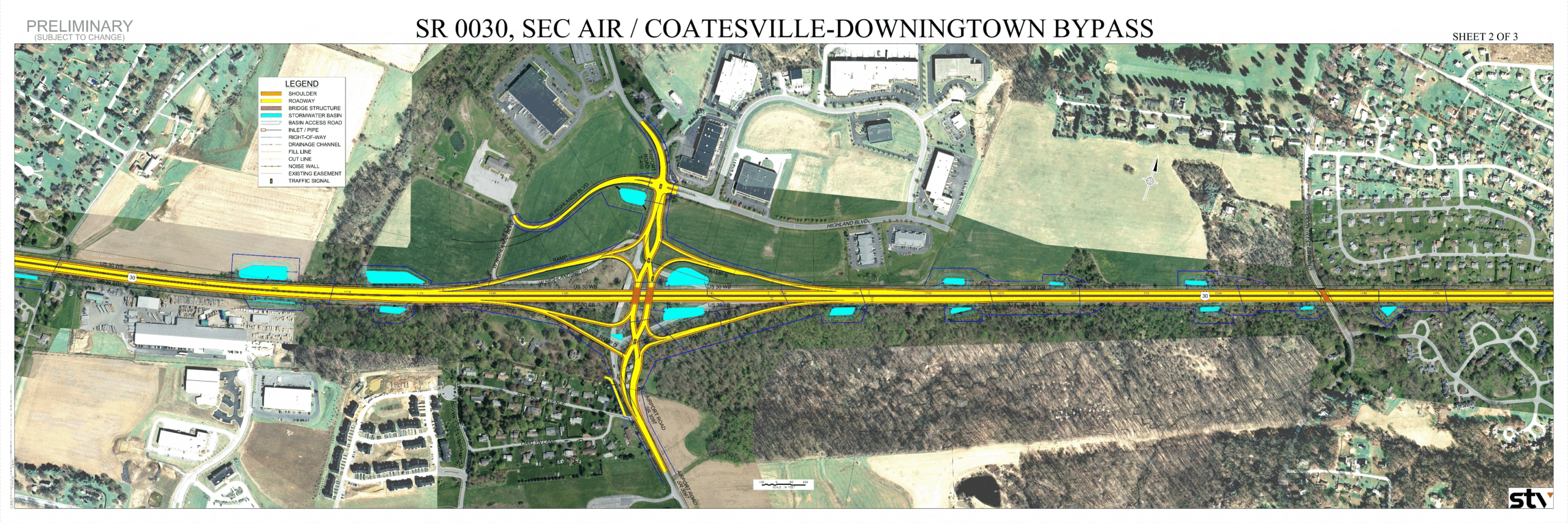
The selected alternative for the Airport Road Interchange is a Diverging Diamond Interchange. It provides a full movement interchange with Eastbound and Westbound on and off ramps. Within the interchange area, two structures will carry Airport Road over US 30 mainline. West Highlands Boulevard is relocated from its existing location to continue to provide access to the Moose Lodge via a four-leg, signalized intersection at Airport Road.
Airport Road Interchange Selected Alternative – Diverging Diamond Interchange
A video clip can be viewed below, which shows an example of a Diverging Diamond Interchange from the driver perspective. A key feature of the Diverging Diamond Interchange is that it creates two signalized crossover points which eliminates the need for left-turning vehicles traveling onto or off the interstate to cross paths with approaching through vehicles. The video clip demonstrates how the design is able to achieve these movements, while giving the driver an experience that is much like any other roadway design.
The Airport Road Interchange provides two traffic signals for the crossover points, with signalization of the left-turn off-ramp movements as well. A traffic signal is also provided at Airport Road and Highlands Boulevard. All of the traffic signals will be interconnected with synchronized operations and timings.
The project will also provide improvements at the intersection of Airport Road and US 30 Business. The horizontal curvature along Airport Road north of US 30 Business will be improved. Additional capacity will be added for the predominant movement traveling eastbound along US 30 Business to turn left onto northbound Airport Road with the addition of a left-turn lane. The intersection geometry and radii will also be modified to improve movements for large trucks.
ENVIRONMENTAL EVALUTION
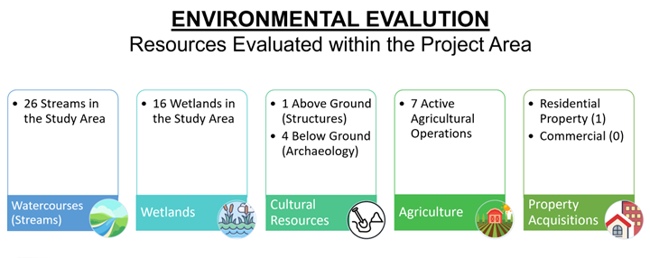
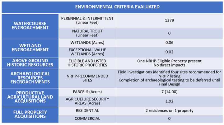
Some of the significant environmental features of the project area include farmland, two churches, township open space, archaeological sites, one historic property, 26 streams, and 16 wetlands. A total of seven active agricultural parcels are present. All or part of two of these operations are enrolled in an Agricultural Security Area. Several agricultural parcels are planned for development. The Gateway Grace Community Church and the Valley Baptist Church are located to the south of US 30 with the church buildings set back from the project’s footprint. Township and Home Owner Association open space abuts stretches of the project corridor to the east of Country Club Road. Much of this land is wooded and contains several wetlands and streams. One of those streams is Rock Run, the main watercourse in the project area. In addition to Rock Run, 24 unnamed tributaries to Rock Run, Mineral Springs Creek, and one unnamed tributary to Buck Run lie within the project area. A total of 16 wetlands with vegetation ranging from predominantly herbaceous cover to predominately tree cover are found in the project area. There is one property, known as the Old Greenwood Place, adjacent to the project area but not impacted by the project, that is listed as eligible for the National Register of Historic Places.
A summary of the environmental evaluation and a matrix of the environmental criteria evaluated is provided below.
NEXT STEPS
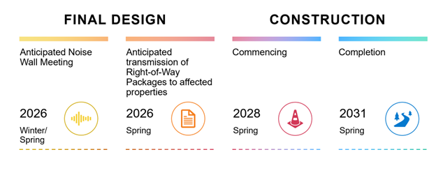
The project will move into the Final Design stage. During this stage, it is anticipated that the project team will conduct a meeting regarding noise walls in the summer of 2025. Also, Right-of-Way packages are anticipated to be transmitted to affected properties in the autumn of 2025. At this time, it is estimated that construction will comment in the spring of 2028 and conclude in the spring of 2031.
NOISE IMPACT
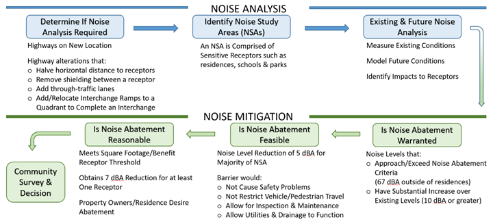
The following graphic illustrates the steps within the noise evaluation process. The use of noise barriers is being evaluated during the Preliminary Engineering and Environmental Evaluation phase. Additional public meetings and special process meetings will be held as the project progresses to discuss the possible use of noise barriers. For the Airport Road Project Area (Section AIR), it is anticipated that the project team will conduct a meeting regarding noise walls in the summer of 2025. The Noise Report, finalized by the project team in October 2024, can be reviewed here.
RIGHT-OF-WAY INFORMATION
Since the Airport Road Project Area (Section AIR) is currently in the Preliminary Engineering stage, property impacts are not yet known. Should your property be needed for transportation purposes, you will be contacted, and you may be assured that PennDOT’s Right-of-Way Representatives will gladly answer any questions you may have. You may also be assured that it is PennDOT’s intention to achieve the best possible transportation facilities while maintaining your satisfaction as a private landowner. More information about the acquisition process can be found in PennDOT Publication 83. For the Airport Road Project Area (Section AIR), Right-of-Way packages are anticipated to be transmitted to affected properties in the autumn of 2025.


