EASTERN PROJECT AREA (SECTION CER)
Eastern Project Area (Section CER) Virtual and In-Person Public Events (Updated January 2026)
The Pennsylvania Department of Transportation (PennDOT) invites the public to attend an in-person open house plans display for the U.S. 30 Eastern Project Area (Section CER). The project team will present the selected alternatives for U.S. 30 mainline and the Reeceville Road, Route 340, and Route 322 interchanges, and the revised alternatives for the Norwood Road and Route 113 interchanges.
This project is one of a series of projects that will upgrade a 14.5-mile section of the U.S. 30 (Coatesville-Downingtown Bypass) corridor to improve safety, reduce congestion, accommodate planned growth, and improve system connectivity.
A virtual public meeting for the U.S. 30 Eastern Project Area, Section CER was held on Thursday, January 15, 2026. A recording of the virtual presentation can be viewed here.
A summary of the questions and answers from the virtual public meeting can be viewed here.
An in-person open house plans display for the U.S. 30 Eastern Project Area, Section CER will be held:
Date: Tuesday, January 20, 2026
Time: 6:30 PM to 8:30 PM
Location: Pope John Paul II Regional Catholic Elementary School
2875 Manor Road, Coatesville, PA 19320
Click here for a map of the school and location details for the in-person event.
Scroll to the bottom of this page to submit a comment form to provide your input. Comment form submissions are due by Friday, February 6, 2026.
INFORMATION PRESENTED FOR PUBLIC REVIEW & INPUT
(POSTED JANUARY 2026):
WELCOME AND PROJECT BACKGROUND
Thank you for visiting the project website. The U.S. 30 Reconstruction program includes a series of projects that will upgrade the Coatesville-Downingtown Bypass (U.S. 30) to improve safety, reduce congestion, accommodate planned growth, improve facility deficiencies, and improve system connectivity. In late 2021 and early 2022, PennDOT hosted public involvement activities to present improvement alternatives for the Eastern Project Area of U.S. 30 (Section CER). Based on the technical evaluation of alternatives and input received during the public outreach, alternatives were selected for U.S. 30 mainline and at Reeceville Road, Route 340 and Route 322. A new set of alternatives at Norwood Road and Route 113 have been developed for public review and input.
EASTERN PROJECT AREA OVERVIEW - INTERCHANGE LOCATION MAP
EASTERN PROJECT AREA SELECTED ALTERNATIVES
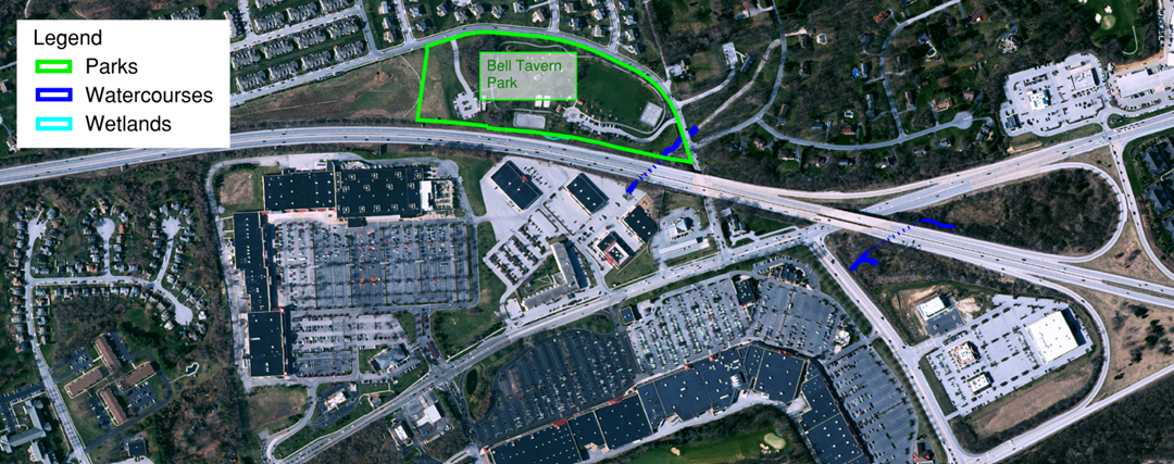
REECEVILLE ROAD AREA OVERVIEW MAP
REECEVILLE ROAD INTERCHANGE SELECTED ALTERNATIVE
- Full Diamond Interchange at Reeceville Road to replace the existing interchange.
- Fisherville Road will be relocated to the north between the CVS and the Wawa. Fisherville Road will be stop controlled at Reeceville Road.
- The U.S. 30 eastbound and westbound ramp intersections with Reeceville Road will be signalized.
ROUTE 340 AREA OVERVIEW MAP
ROUTE 340 INTERCHANGE SELECTED ALTERNATIVE
- Full Diamond Interchange, larger than the existing interchange to accommodate longer ramps.
- Single Lane Roundabout at the U.S. 30 westbound ramp intersection, eliminating the existing traffic signal.
- Stop Control on the U.S. 30 eastbound ramp intersection.
- West Bondsville Road will be relocated to the north to maintain access to residential homes.
ROUTE 322 AREA OVERVIEW MAP
ROUTE 322 INTERCHANGE SELECTED ALTERNATIVE
- Diverging Diamond Interchange (DDI) creates two signalized crossovers to eliminate the need for left-turning vehicles to cross paths with approaching through vehicles.
- The U.S. 30 westbound off-ramp right turn at Route 322 will also be signalized.
- The PennDOT maintenance facility is maintained.
- Driveways for the PennDOT Park & Ride and the Royal Farms are impacted, which may result in access restrictions to right-in/right-out movements only.
Click here for educational information about Diverging Diamond Interchanges.
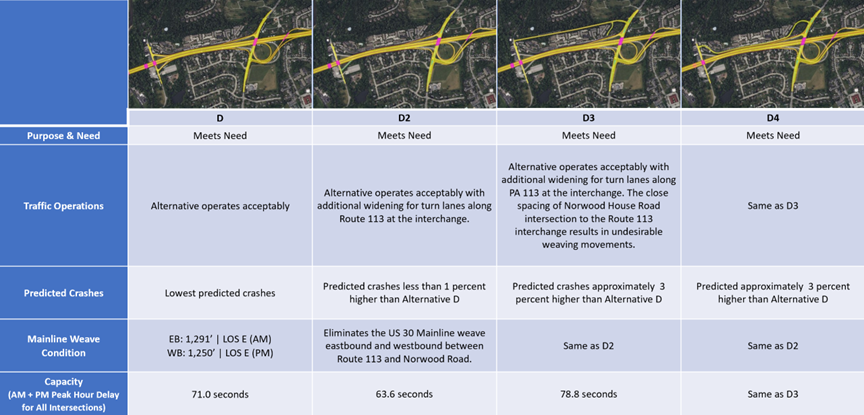
NORWOOD ROAD & ROUTE 113 REVISED INTERCHANGE ALTERNATIVES FOR PUBLIC REVIEW & INPUT
NORWOOD ROAD & ROUTE 113 AREA OVERVIEW MAP
NORWOOD ROAD & ROUTE 113
ALTERNATIVE D
- Includes a westbound flyover off-ramp to Route 113.
- Exit/Entrance ramps to/from Norwood Road remain in the existing configuration.
NORWOOD ROAD & ROUTE 113
ALTERNATIVE D2
- Norwood Road eastbound on-ramp is closed to the public and in use only for emergency services providers.
- Norwood Road westbound off-ramp is removed.
- Norwood House Road remains in the existing configuration. Traffic calming will be installed to discourage its use as a direct connection between Norwood Road and PA 113. Norwood Road traffic will utilize Garris Road to the north or Route 282 and Pennsylvania Avenue to the south to access the new Route 113 full interchange.
NORWOOD ROAD & ROUTE 113
ALTERNATIVE D3
- Ramps at Norwood Road are removed.
- Norwood House Road is relocated to the north to serve as a direct connection between Norwood Road and Route 113. Since capacity at the Norwood House Road intersection at Route 113 is limited, some Norwood Road traffic will utilize Garris Road to the north or Route 282 and Pennsylvania Avenue to the south to access the new Route 113 full interchange.
NORWOOD ROAD & ROUTE 113
ALTERNATIVE D4
- Ramps at Norwood Road are removed.
- Norwood House Road remains in the existing configuration for use as a direct connection between Norwood Road and Route 113 with modifications appropriate for a speed limit of 25 miles per hour.
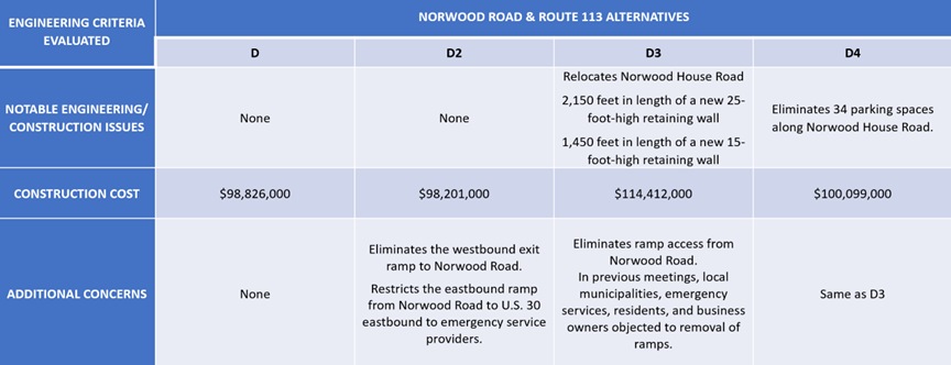
NORWOOD ROAD & ROUTE 113 DECISION MATRICES
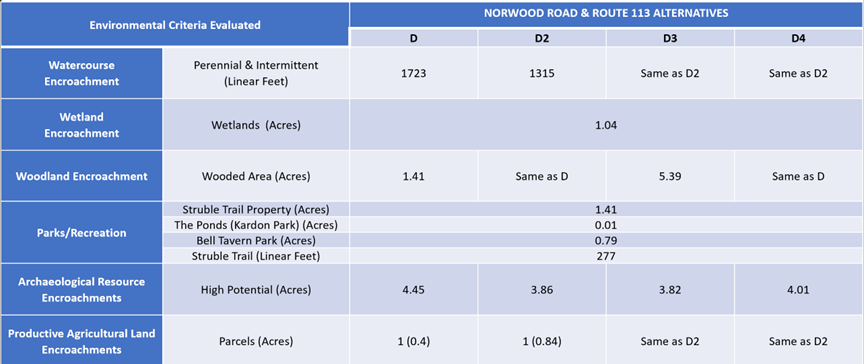
NORWOOD ROAD & ROUTE 113 KEY ENVIRONMENTAL RESOURCES MAPS
NORWOOD ROAD AREA
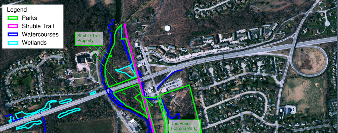
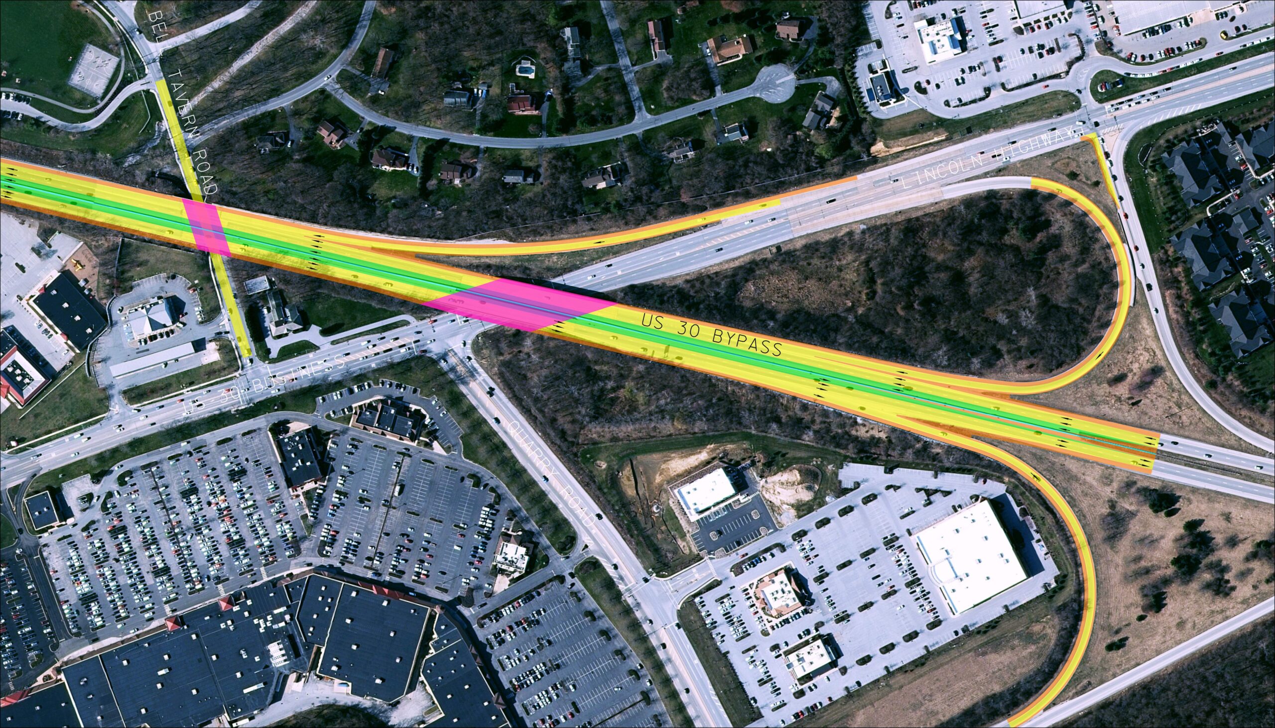
QUARRY ROAD AREA
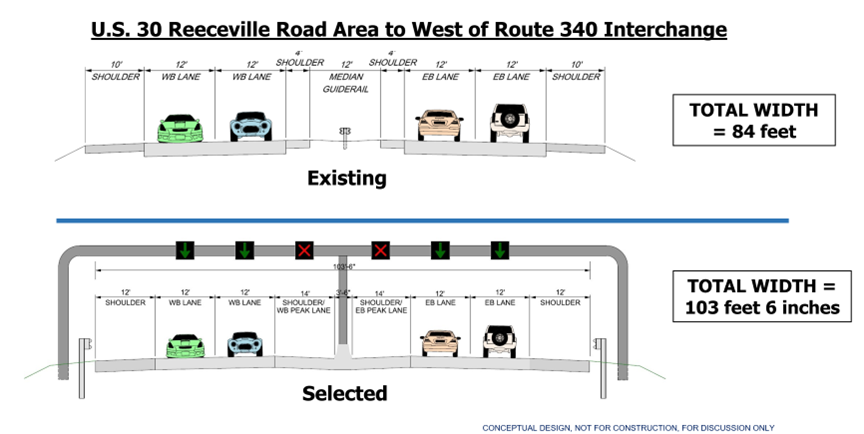
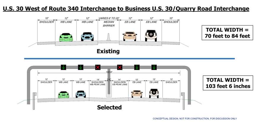
U.S. 30 MAINLINE SELECTED ALTERNATIVE
BUSINESS U.S. 30 & QUARRY ROAD INTERCHANGE SELECTED ALTERNATIVE
NOISE IMPACT
The Western Terminus/Route 10 Project Area (Section 10) is currently in the Conceptual Design phase, which will take approximately one year to complete. The next phase will be Preliminary Engineering and Environmental Evaluation, which is anticipated to last approximately two to four years. Final Design will follow, with a two-to-four-year timeframe.
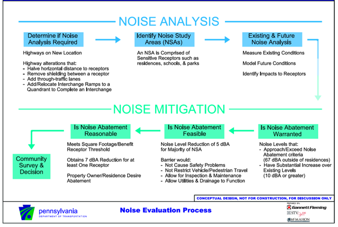
The following graphic illustrates the steps within the noise evaluation process. The use of noise barriers will be evaluated during the Preliminary Engineering and Environmental Evaluation phase. Additional public meetings and special process meetings will be held as the project progresses to discuss the possible use of noise barriers.
NOISE EVALUATION PROCESS
RIGHT OF WAY INFORMATION
Since the Western Terminus/Route 10 Project Area (Section 10) is currently in the Conceptual Design phase, property impacts are not yet known. Should your property be needed for transportation purposes, you will be contacted, and you may be assured that PennDOT’s Right-of-Way Representatives will gladly answer any questions you may have. You may also be assured that it is PennDOT’s intention to achieve the best possible transportation facilities while maintaining your satisfaction as a private landowner. More information about the acquisition process can be found in PennDOT Publication 83.
PROVIDE YOUR INPUT
Based on the information, please click on the button below to complete and submit a comment form to provide your input. Comment submissions are due by Friday, February 6, 2026.

DECEMBER 2021 - FEBRUARY 2022 PUBLIC INVOLVEMENT
A virtual open house was hosted to present the conceptual design work and alternatives for the Eastern Project Area (Section CER), from just west of the Reeceville Road interchange to the Quarry Road / Business U.S. 30 interchange for public input. The information presented at that time can be viewed here.